1. ZHABESHI-ADISHI TRAIL
The first portion of the trail begins 1,690 metres above sea level near a
mineral water spring atop the village of Zhibeshi, where we see the following
signs painted on a rock: "START - 1690" and "MW" (mineral water). We head
southwest and follow the farmers' road. About 500 metres from the start we come
across a sign painted on shale. To our right is the Laghvi Church of Saint
George.
At 2,050 metres we see a rhododendron grove and marker No 2, which indicates
that drinking water is available nearby. We enter a forest of birch trees and
rhododendron bushes. From here to the north we look down on the village of
Zhabeshi and the Tviberi valley (Picture 1), to the northwest we see the Mulakhi
community villages of Lakhiri and Cholashi in the Mulkhara valley at the base of
Mount Banguriani (Picture 2). To the east is Tetnuldi, a snow-capped cone-shaped
rock formation (4,860 m). We continue down the sledge route and pass coniferous
and mixed forests. After one hour, at an elevation of 2,120 metres, the road
forks. Here, an arrow marked on a birch tree in a rhododendron patch points to
the east. To the north we see the south face of Banguriani Mountain,
Komsomolskaya Peak and to the left - Mount Ushba, to the northeast - the
Tsaneri-Tviberi Ridge.
The route heads east through along the ridge. Our elevation steadily
increases until we reach a plateau at 2,700 metres. From here we look out upon
the Inguri River valley; far to the west we see the village of Tsvirmi, the
Ughviri mountain pass and the Zuruldi ridge (Picture 3); to the east is the
aforementioned Tetnuldi (4860m). The road forks here, with the east path
remaining on the plateau, and the right descending southward. A marker indicates
that the latter is our route. We descend quickly and after two kilometres we
reach an elevation of 2,350 metres, where we come across another fork in the
road. We take the right fork, which leads to cattle farms a few hundred metres
down the road. On the right are grazing pastures (Picture 4). Soon the village
of Adishi comes into view (Picture 5). We cross a stream bed and enter Adishi,
where we rest our horses and spend the night.
At a leisurely pace, this portion of the trail takes 5-6 hours.
2. ADISHI-IPRALI
The route begins atop the village of Adishi, by a foot-bridge over the right
tributary of the Adishistsqali River (2,030 metres). To the left of the bridge
our start marker "SII" is painted on an old tower, as is an arrow pointing our
way (Picture 1). To the left of the foot-bridge is an old water mill. The route
follows along the right bank of the Adishistsqali.
Two kilometres from the start, at an elevation of 2,200 metres, we cross a
stream and 50 metres to the left of the path we see the Chaneshi Church of Saint
George and the ruins of a tower. About 200 metres from here, the path leads into
a meadow that was once levelled by an avalanche, where signs are marked on
several rocks. We continue along the right bank and, after about one hour from
the start, we see the Lardaadi glacier, which locals also refer to as the Adishi
glacier (Picture 2). This glacier takes shape on the south slopes of the
Tetnuldi-Adishi mountain range and descends to 2,400 metres. It is the source of
the Adishischala River. Near this place (2,390 m) we cross the river and follow
steep slopes covered in mixed forest. The path takes us towards the Chkhutnieri
pass (2,720 m) (Picture 3). This mountain pass crosses the ridge that separates
the Adishischala and Khaldeschala river basins. This stretch is difficult, so we
will need to dismount from our horses often. At 2,420 metres a small stream
flows onto a 150-200 metre stretch of the path, which creates additional
difficulties. From the Chkhutnieri we get a good view of the road we have
travelled since Adishi. From the mountain pass we descend along the ridge to the
basin of the Khaldeschala River. At 2,400 metres the road forks. One path leads
to the east and the other to the south. A marker here indicates that we take the
latter, southward path on our right. Below we see farmers' summer cabins. After
descending to 2,200 metres, we approach the Khaleschala and follow along its
right bank up to the village of Khalde (1,900 m). On the way we see a tall
waterfall (Picture 4).
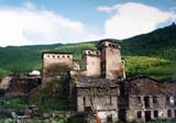
Khalde has somewhat of a tragic history. It is famous as the site of
rebellions against Tsarist Russia, as village residents refused to obey their
conquerors. They fought to the end, as a result of which Russian forces
completely destroyed the village with all its towers (Picture 5). Since then the
village has never recovered, and now is populated by only a few families in the
summertime. To this day, Svans recall the heroes of Khalde with great respect.
Svans often dance to a song composed in their honour entitled "Gau-gavkhe"
(Picture 6)
From Khalde we again descend down the right bank of the river to the village
of Iprali (Picture 7), where the second section of our trail ends.
We are now in the community of Kala, in the Inguri River valley. This
community includes six villages, two of which - Lalkhori and Davberi - we will
pass on the third part of our journey. From Iprali to the south we can see the
Svaneti Ridge, which separates the Inguri and Tskhenistsqali River basins
(Picture 8). From this point it is possible to cross into the Tskhenistsqali
valley via the Mushuri mountain pass. This is Kvemo-Svaneti (Lower Svaneti), the
Lentekhi District. We cover the distance from Adishi to Iprali in 4-5 hours.
Directly ahead of us, across the Inguri at a distance of about 1.5 km to the
west, we can see one of Svaneti's most important churches - that of Saint
Kvirike (Picture 9). If you have enough energy, you can visit this site as well.
3. IPRALI-USHGULI
The third part of the trail begins in the village of Iprali at an elevation
of 1,890 metres above sea level. The "START" marker is painted on the house of
Ucha Margvliani. From here we descend to the village of Lalkhori (Picture 1). We
follow the automobile road along the Inguri River in the direction opposite its
flow (Picture 2) and soon we enter the village of Davberi. From here we follow
the sledge road (Picture 3). At an elevation of 2,000 metres, we come across a
fork in the road, the right fork connects with the automobile road and the left
one follows along side the slants. A marker tells us to take the left fork. We
follow the twisted slants (Picture 4), which ranges in elevation from 2,000 to
2,200 metres. After about three kilometres, at an elevation of 2,000 metres we
come across a spring. Another 200 metres from the spring the trail forks again.
The left fork leads upwards to the mountains, while a marker tells us to take
the right fork, which leads eastward, to the slant. Later the path crosses a
stream and enters a "corridor" of birch trees. We must be careful here not to
run into branches as we sit atop our horses.
After another 200-300 metres we come to an intersection, where we turn right.
To our right we notice a pine tree that has been split by lightning. We then go
down to the bank of the Inguri River. Here, at an elevation of 2,050 metres, a
sign "FU-1km" painted on a large boulder indicates that we are nearing the
finish. After one kilometre we come to the community of Ushguli, which brings
together four villages (Murqmeli, Chazhashi, Chvibini and Zhibiani).
Three to four hours after leaving Iprali, a beautiful panorama unfurls before
us - we surrounded by the middle-age towers of Ushguli (Pictures 5,6,7)
|
|

 ROUTE MENU
;)
;)
;)
;)
;)
;)
;)
;)
;)
;)
;)
;)
;)
;)
;)
;)
;)
;)
;)