WHERE IS SVANETI?
Georgia is situated on the South slopes of the Greater Caucasus Range and
Small (South) Caucasus Highland. The radially oriented Surami Range, dividing
Georgia into two parts - East and West Georgia, connects these two mountain
massifs. The highest and the roughest mountains of Caucasus are on Georgia's
side of the range, stretched on the area of about 700 km. It's more than one
third of the whole country's territory and its average elevation equals 3,520
meters.
The mountainous massif of Caucasus is stretched over 1,300 km from Taman
peninsula to Apsheron. There are hundreds of snowy and icy peaks and passes on
its main range and side branches. The fifteen of the mentioned peaks are higher
than the highest peak of Alps - Mont Blanc (4810 m) and six of them are more
than five thousand meters in height: Elbrus (5642 m.), Shkhara (5068 m.), Distau
(5200 m.), Jangha (5059 m.) Mkinvartsveri (5033 m.) and Koshtantau (5152 m.)
The central, 125 km part of the West Caucasus, starting from Kodori range and
ending at the Pasi Mountain, is called Svanetian Caucasus. Svaneti, which is the
highest region in Georgia settled by people, is located on its South slopes.
Svaneti includes gorges of the rivers Inguri and Tskhenistsqali from their
midstream to the headwaters. Zemo (or upper) Svaneti is presented by the
district of Mestia, which is a small town and the administrative centre giving
the name to the district; Kvemo (or lower) Svaneti is likewise presented by the
administrative district of Lentekhi.
Svaneti harbours the major Caucasus peaks and the largest glaciers, the total
area of which equals 300 sq. km. They hang over the Caucasus Mountains like an
icy crown. The most important mountains are Tsurungala (4220 metres above the
sea level), Ailama (4550 m.), Shkhara (5068 m.), Jangha (5060 m.), Gestola (4860
m.), Tikhtingen (4620 m.), Tetnuldi (4860 m.), Mazeri (4010 m.) and Chatini
(4370 m.) that are neighboured by a well-known steep rock massif of twin-headed
Ushba (4700 m.). Ushba is a paragon of a natural beauty and complexity among the
Caucasus Mountains, similar to Matterhorn (4478 m.) in Alps.
The average absolute elevation of the Caucasus ridge is up to 4125 m. The
maximum altitude is 5068 m. (Shkhara), and minimum altitude is 3168 m.
(Donghuzoruni pass). There are some twenty passes of different complexity in
this area of Caucasus that are directed towards the North side - the territory
of Russian Federation. The height of the passes varies from 3160 meters to 3860
meters above the sea level. Some of the paths are good for pack animal hiking:
horses or mules, but most of them could only be used on foot, yet, there are the
paths that could be surmounted only by the mountaineers and alpinists.
The highest among the branches of the South Caucasus is the Svaneti range
(with the highest peak of Lahili - 4010 m.) that is a watershed between the
rivers Inguri and Tskhenistsqali. It is 120 km. long and approximately 2630
meters above sea level.
|

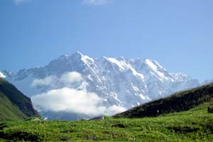
Shkhara (5068m)
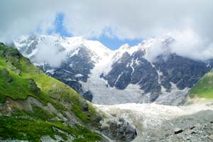
Shkhara Glacier
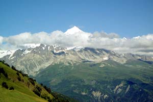
Tetnuldi (4860m)
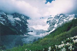
Tetnuldi (Adishi) Glacier
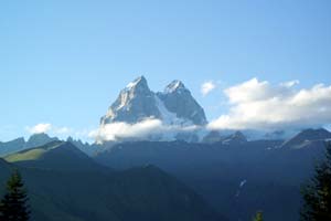
Ushba (4700m) view from the south
(V.Naveriani's photo)
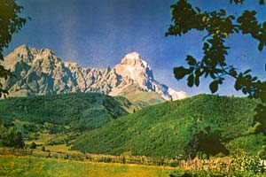
Ushba view from the west
(G.Tikanadze's photo)
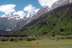
Shikhra Valley, Dolora river gorge
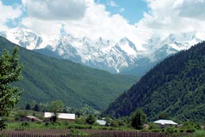
Svaneti Range (4010m) view from Tchokhuldi village
|

 ABOUT SVANETI